
Riding to Half Moon Bay at dusk.
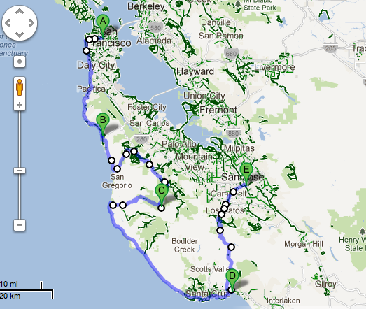
Some friends and I did a rad 5 day, 4 destination bike trip capitalizing on a weekend by taking Monday and Tuesday off work. This ride is great for in-shape beginners to intermediate riders as most days are 40-50 miles. Google Maps says we rode about 160 miles overall, but according to a friend’s bike computer it was closer to 200. This is the route we did:
San Francisco
Half Moon Bay State Beach Park (30 miles)
Portola Redwoods State Park (40 miles)
New Brighton State Beach Park (57 miles)
Tamien Caltrain Station in San Jose (36 miles)
* Our original plan was to have a 5th destination, Henry Coe State Park, in between New Brighton and Tamien, which we ended up skipping in favor of a rest day. It is 45 miles from New Brighton to Henry Coe and about 40 from Henry Coe to Tamien Caltrain.
 Route:
Here’s a Google Map of our route, with some insider tips we used for good cycling roads. Post a comment and share if you find better roads or trails. I find the best people to ask are cyclists you meet en route, they’re usually from the area and have the skinny on bike-friendly roads and the geography.
Hiker/Biker (H/B) Camp Sites:
Hiker/Biker camp sites can be found in state parks throughout California and Oregon (not sure about other states, I’ve only toured the West Coast). Check the state park systems website or call to see if they have hiker/biker. I’ve seen all kinds of hiker/biker camp sites. Some are really nice with individual sites, fire rings and picnic tables. Some have a communal tent site, one camp ring and a few picnic tables. Others have a combination, or anywhere in between. The areas more frequently traveled by cyclists tend to have the nicest hiker/biker sites. H/B costs $5 per person and are drop in/first come, first served. I’ve never encountered a full H/B site, though. If you come to a camp site with no H/B, most people are willing to share their regular camp site with cyclists because of our light loads and hard work (you can always bush camp too, but I personally like having a shower while bike touring). There’s always a way. Back to H/B though. If you arrive after the ranger station is closed, fill out the envelope, include your payment and drop it in the box. There should be a map posted at the ranger station with the location of the H/B. All the parks on this route have premium H/B sites.
Stats Sourced: www.foldingbikezone.com/best-hybrid-bicycles-300/
San Francisco – Half Moon Bay (HMB)
Friends and I met on the Panhandle in San Francisco around 7pm. The ride was beautiful – through Golden Gate Park and south along the Great Highway, following Ocean Beach. My favorite is when the Great Highway is closed to cars due to windblown sand, which was the case for us that Friday. At this point it started getting dark and we ended up doing at least 20 miles in the dark. I would not recommend it. There were many miles without a shoulder in the pitch black. HMB State Park is beautiful though, worth every excruciating mile in the dark with a tiny red blinking light and a headlamp to forge the way. The H/B site is toward the back of the campground, you follow the path parallel to the ocean on the other side of the ranger station. It was difficult to find in the dark because the path leads up to the back side of the H/B. The picnic tables and fire rings are on the ocean side along with some bathrooms. The park is literally right on the beach and so we were able do beach yoga in the morning which was refreshing after our 11:00pm arrival and mad cooking session before bed. FYI it was very cold at night while we were there, being right off the ocean.
Half Moon Bay – Portola Redwoods
This was our no pain, no gain ride. Portola Redwoods State Park is a well kept secret. I imagine it is overlooked in favor of Big Basin State Park, also in the area. We rode inland especially for this location as an experienced tourer friend told us it is his favorite ride and park with H/B.
Take special note of the route we took as we ammended it from the recommended Google Maps route. We left Saturday morning, getting back on Cabrillo Hwy/Hwy 1. You make a left on Tunitas Creek Road, which is after Purisima Creek Road and Lobitos Creek Road. Tunitas is a side route on an isolated road well traveled by local cyclists. It is gorgeous, but the trade-off is a couple hours of climbing through 4,500 feet of elevation. Before you start the climb though, you will see the Bike Hut a couple miles down Tunitas from Cabrillo Hwy. Stop here for some snacks and to fill up on water. They even had some organic chicken and beef in the freezer, I assume from the farm the Bike Hut is located on. You pay by trust as there is no one tending the Hut. After the climb and beautiful scenery, and you just don’t think life could be any better you encounter an unbelievable descent into the Park for the last 30 minutes of the ride. Alpine Road winds blissfully downhill for miles of rare color and nature-scapes.
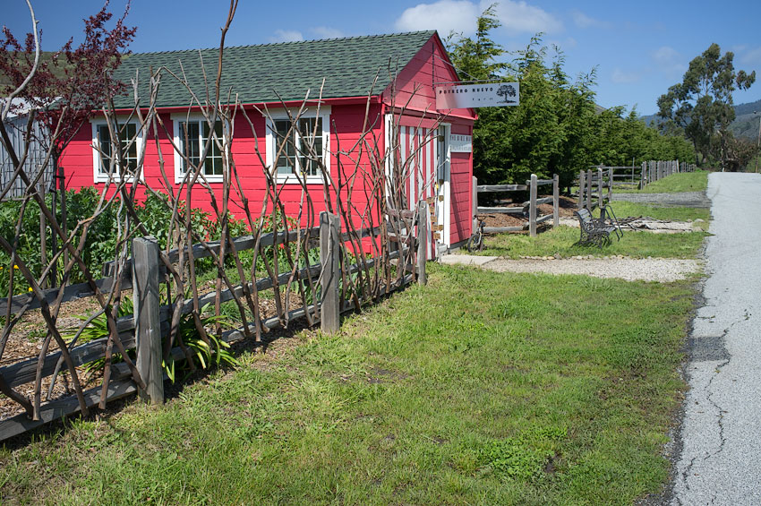
The Bike Hut, photo from diglloyd.com
Another reason to visit Portola Redwoods in the near future is it is one of the CA State Parks slated for closure July 2012, so you don’t have much time. Portola Redwoods is unusual in the fact that the climate, low in a valley, is dry and warm unlike most redwood areas which tend to be damp. I also did not see any raccoons, which also seems to be a hallmark of redwood parks. The H/B site is rad; individual sites and cool fire pits/grills. There are definitely people around, but the park has a quaint vibe evidenced by the fact the ranger leaves firewood bundles out at night for those who arrive late and pay is again based on trust.
Portola Redwoods – New Brighton
Take special note of the route leaving Portola Redwoods on the map. It is a far superior route to leaving the park climbing the descent you rode in on. The “unknown road” the Google Map refers to is a Service Road that links to the park near the regular camp sites past the Ranger Station (ask the ranger, they’ll direct you.) The Service Road is a trail that leads you to Old Haul Road, another dirt trail. This links up to Pescadero Creek Road after 6 or so miles of trail riding. You head West back toward the coast passing the little town of Pescadero. You may be tempted to take a side road to get back to Highway 1 called Cloverdale. We didn’t think it was worth the risk of encountering elevation as Pescadero Creek Road was flat and pleasant. This ride, despite its length, was not as challenging as you might think. You are riding on Hwy 1 for most of it, parallel to the ocean. Also, the descents are so intense that most of the time I had enough speed to get to the top of the inclines of this roller coaster type ride. It was exhilarating and spectacular, probably my favorite ride of the trip. Once you get close to Santa Cruz there is a paved bike path off of Hwy 1 to take into the city and then some side routes that get you to the Park outlined on our Google Map.
We were pretty exhausted after the climbing on Saturday and then almost 60 miles on Sunday, so Monday we decided to take a rest day instead of biking to Henry Coe State Park. Technically, New Brighton has strict rules about their hiker/biker (I’ve not found this anywhere else), restricting stay to one night. We asked to stay a second, which the park ranger granted us. Ranger Nick is pretty chill. You’re also supposed to vacate the H/B by 9am, but we weren’t ready to go until noon and were only “encouraged” to hurry up once. This park has really nice bathroom/shower facilities across the way from H/B. The camp host was super nice, and even though they were closed provided us with quarters for a shower being sympathetic to our needs as cyclists. We encountered the most cyclists at this camp site. It’s always fun to commune with other bikers.
New Brighton – Tamien Caltrain
Tuesday we rode from New Brighton to San Jose’s Tamien Caltrain. Take special note of Morril Road. It has lots of dips and climbs, but it cut off several miles of Summit Road and was fun. You then loop around Lexington Reservoir (stop and have lunch on their beach about ¾ way around the Reservoir), and then catch a dirt running/bike trail off to the right which after many miles leads you into San Jose. You can leave the trail after a couple miles in favor of road riding down Los Gatos and then South Bascom, but the trail seems like the better option. Check Tamien’s Caltrain schedule before you go as the service is intermittent. The ride is $8 back to the city, the train car for bikes is in the rear. Et voila, you’re back in the city in over an hour.

This trip was amazing, with every day and ride a new and unexpected experience. Additonally, there are so many other variations you could do with this route. We had a friend from Oakland BART to Daly City and do a 75 mile ride to meet us at New Brighton. You could also BART to Fremont which would make for a shorter ride. I will leave the investigating up to you.
Logistics are one thing, but what you really need for this type of venture is the gumption to just go out there and do the damn thing. Sometimes it’s tough to break away from your life in the city, but there is nothing more exhilarating to me than biking to a new destination with everything I need on my bicycle. Grab a friend or two, your gear, check a map and don’t be afraid to ask folks for assistance along the way. Bike touring is all about immersing yourself in the communities of humans and nature you pedal in to. There are expansive possibilities for world-class bike touring in the Bay Area – embrace them!